
The full moon rises high and clear over the Chihuahuan Desert. It’s autumn in the late 1700s. A couple of centuries from now—at the end of the 20th Century—the full moon at this time of year will bear the benign name Harvest Moon. But, in the 1700s, the inhabitants of northern Mexico call this the Comanche Moon.
PAGE CONTENTS

Each year, around the time of this autumn full moon, Comanche warriors paint their bodies and mount wild horses descended from Spanish stock. They start out from springs near Fort Stockton, Texas. They sweep through the Big Bend region headed south for Mexico, along modern-day Highway 385.
According to a handbook of the National Park Service for Big Bend National Park, the Comanches “forded the Rio Grande at present-day Lajitas, picked Mexico clean as far south as Durango, and turned home at the end of the year. Driving captives and herds of horses and cattle northward, they probably recrossed the Rio at Paso de Chisos just to the west of Mariscal Canyon. We are told that for decades after the last Comanche left Big Bend, the great War Trail burned like a white scar across the landscape, scuffed bare by countless hooves.”
Big Bend Plane flight Terlingua Texas
More info:

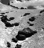
Photo courtesy of Dr. Gentry Steele
Many thanks are due to Dr. Gentry Steele of Texas A&M University in College Station, Texas for inspiration and insights into the Big Bend region. His understanding of the cultural and natural history of the region is astounding. And his photographs capture the spirit of the desert better than my words could ever do.
Web Sites:
- Big Bend National Park – http://www.nps.gov/bibe/index.htm
Books:
- Gentry Steele, Land of the Desert Sun, Texas A& M University Press, College Station, 1998.
- Big Bend, Official National Park Handbook 119, Division of Publications, National Park Service, U.S. Dept. of the Interior, 1983.
- Fredrick Gehlbach, Mountain Islands and Desert Seas.
- Ross Maxwell, The Big Bend of the Rio Grande, Guidebook 7. Texas Bureau of Economic Geology, 1968.
- Ross Maxwell, Geological History of Big Bend.
- Kenneth Ragsdale, Big Bend Country: Land of the Unexpected.
- W.D. Smithers, Chronicles of the Big Bend, Austin: Madrona Press, Inc., 1976.
- Roy Swift, Three Roads to Chihuahua, Eakin Press.
- Susan Tweit, The Great Southwest Nature Factbook.
- Ronald H. Wauer, The Naturalist’s Big Bend, Texas A&M, 1980.
Water and Rocks | Making a Desert | Fossils | Adaptations | People of the Desert | Ranching